
Filter by
SubjectRequired
LanguageRequired
The language used throughout the course, in both instruction and assessments.
Learning ProductRequired
LevelRequired
DurationRequired
SkillsRequired
SubtitlesRequired
EducatorRequired
Results for "geographic information systems"

University of California, Davis
Skills you'll gain: ArcGIS, GIS Software, Spatial Analysis, Data Storytelling, Spatial Data Analysis, Geographic Information Systems, Data Presentation, Data Sharing, Geospatial Mapping, Geospatial Information and Technology, Land Management, Heat Maps, Epidemiology, Metadata Management, Data Mapping, Data Visualization Software, Data Quality, File Management, Network Analysis, Data Modeling
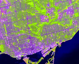
University of Toronto
Skills you'll gain: ArcGIS, GIS Software, Spatial Data Analysis, Spatial Analysis, Geographic Information Systems, Geospatial Mapping, Geospatial Information and Technology, Data Mapping, Data Visualization, Metadata Management, Query Languages, Data Manipulation, Data Synthesis, Quantitative Research, Data Compilation, Data Processing, Typography, Data Cleansing, Data Validation, Data Storytelling
University of California, Davis
Skills you'll gain: ArcGIS, GIS Software, Data Sharing, Geographic Information Systems, Geospatial Mapping, Metadata Management, Data Quality, Data Mapping, File Management, Data Import/Export
 Status: Free
Coursera Instructor Network
Skills you'll gain: Geographic Information Systems, Geospatial Information and Technology, Geospatial Mapping, Spatial Data Analysis, Global Positioning Systems, Data-Driven Decision-Making
 Status: Free
École Polytechnique Fédérale de Lausanne
Skills you'll gain: Geographic Information Systems, GIS Software, Spatial Data Analysis, Spatial Analysis, NoSQL, Data Modeling, Database Design, Databases, SQL, Data Storage, Data Capture, Data Management, Data Manipulation

University of Michigan
Skills you'll gain: Geographic Information Systems, Geospatial Mapping, Spatial Data Analysis, Spatial Analysis, Interactive Data Visualization, Data Storytelling, Environmental Monitoring, Data Presentation, Forecasting, Trend Analysis

University of California, Davis
Skills you'll gain: Spatial Analysis, ArcGIS, Geographic Information Systems, Geospatial Mapping, Data Quality, Data Mapping, Data Modeling, Data Storage Technologies, Data Storage, Data Processing, Data Manipulation, Databases
University of Toronto
Skills you'll gain: ArcGIS, GIS Software, Spatial Data Analysis, Geographic Information Systems, Geospatial Information and Technology, Geospatial Mapping, Data Mapping, Data Collection

L&T EduTech
Skills you'll gain: Geospatial Information and Technology, Spatial Analysis, Geographic Information Systems, Geospatial Mapping, GIS Software, Database Management, Database Management Systems, ArcGIS, Relational Databases, Decision Support Systems, Data Import/Export, Open Source Technology, Web Applications, Mobile Development

University of California, Davis
Skills you'll gain: ArcGIS, Data Storytelling, GIS Software, Spatial Data Analysis, Data Presentation, Geographic Information Systems, Spatial Analysis, Geospatial Mapping, Geospatial Information and Technology, Heat Maps, Data Visualization Software, Network Analysis, Data Manipulation
 Status: Free
Deep Teaching Solutions
Skills you'll gain: Learning Strategies, Time Management, Willingness To Learn, Mental Concentration, Creativity, Persistence, Self-Discipline, Stress Management, Self-Awareness, Adaptability
 Status: Free
École Polytechnique Fédérale de Lausanne
Skills you'll gain: Geographic Information Systems, Data Modeling, GIS Software, SQL, Database Design, Spatial Data Analysis, Spatial Analysis, Relational Databases, Land Management, Data Capture, Data Storage, Data Management
Searches related to geographic information systems
In summary, here are 10 of our most popular geographic information systems courses
- Geographic Information Systems (GIS): University of California, Davis
- GIS, Mapping, and Spatial Analysis: University of Toronto
- Fundamentals of GIS: University of California, Davis
- GIS Mastery: Spatial Data, Remote Sensing, Decision Support: Coursera Instructor Network
- Geographical Information Systems - Part 1: École Polytechnique Fédérale de Lausanne
- GIS: Geographic Information Systems for Sustainability: University of Michigan
- GIS Data Formats, Design and Quality: University of California, Davis
- Introduction to GIS Mapping: University of Toronto
- Geospatial Information Technology Essentials: L&T EduTech
- Geospatial Analysis with ArcGIS : University of California, Davis


