
Filter by
SubjectRequired
LanguageRequired
The language used throughout the course, in both instruction and assessments.
Learning ProductRequired
LevelRequired
DurationRequired
SkillsRequired
SubtitlesRequired
EducatorRequired
Explore the Cartography Course Catalog

Vanderbilt University
Skills you'll gain: Data Storytelling, ChatGPT, Excel Macros, Excel Formulas, Microsoft Excel, Data Visualization, Spreadsheet Software, Data Analysis, Presentations, Generative AI, Artificial Intelligence, Data Cleansing, Data Import/Export, Data Integration, Productivity Software, Data Transformation, Data Validation, Creative Thinking, Creative Problem-Solving, Natural Language Processing

Coursera Project Network
Skills you'll gain: Canva (Software), Multimedia, Data Visualization, Marketing Design, Brainstorming, Data Sharing, Presentations, Communication

Vanderbilt University
Skills you'll gain: ChatGPT, Generative AI, Image Analysis, Data Capture, OpenAI, Data Analysis, Organizational Skills, Computer Vision, Data Storytelling, Creativity, Artificial Intelligence, Data Integration, Problem Solving, Cooking

L&T EduTech
Skills you'll gain: Geospatial Information and Technology, Spatial Analysis, GIS Software, Spatial Data Analysis, Geographic Information Systems, Geospatial Mapping, Database Management, Database Management Systems, Construction Management, ArcGIS, Relational Databases, Visualization (Computer Graphics), Heat Maps, Civil and Architectural Engineering, Global Positioning Systems, Decision Support Systems, Building Information Modeling, As-Built Drawings, Survey Creation, AutoCAD Civil 3D
MathWorks
Skills you'll gain: Image Analysis, Computer Vision, Matlab, Anomaly Detection, Geospatial Information and Technology, Applied Machine Learning, Data Transformation, Algorithms
Coursera Project Network
Skills you'll gain: Tensorflow, Keras (Neural Network Library), Test Data, Image Analysis, Computer Vision, Artificial Neural Networks, Deep Learning

California Institute of the Arts
Skills you'll gain: Typography, Graphic Design, Graphic and Visual Design, Adobe InDesign, Design, Graphic and Visual Design Software, Design Elements And Principles, Peer Review
 Status: Free
École Polytechnique Fédérale de Lausanne
Skills you'll gain: Spatial Data Analysis, Geospatial Mapping, Geospatial Information and Technology, Geographic Information Systems, Spatial Analysis, GIS Software, Global Positioning Systems, 3D Modeling, Visualization (Computer Graphics), Survey Creation, Systems Of Measurement

Coursera Project Network
Skills you'll gain: Data Visualization, Microsoft Excel, Data Visualization Software, Data Import/Export, Business Reporting, Microsoft 365, User Accounts
 Status: Free
École Polytechnique Fédérale de Lausanne
Skills you'll gain: GIS Software, Spatial Analysis, Geographic Information Systems, Geospatial Mapping, Spatial Data Analysis, Augmented Reality, Sampling (Statistics), Data Mapping, Correlation Analysis, Color Theory

University of Illinois Urbana-Champaign
Skills you'll gain: Data Visualization, Interactive Data Visualization, Data Presentation, Infographics, Data Visualization Software, Data Wrangling, Data Storytelling, Plotly, Matplotlib, Journalism, Graphing, Statistical Visualization, Graphic and Visual Design, Color Theory, Data Manipulation, Data Transformation, Visual Design, Design Elements And Principles
 Status: Free
California Institute of the Arts
Skills you'll gain: Typography, Infographics, Graphic and Visual Design, Computer Graphics, Visual Design, Design, Graphic Design, Graphic and Visual Design Software, Design Elements And Principles, Computer Graphic Techniques, Digital Design, Color Theory, Adobe Photoshop, Adobe Creative Cloud, Creativity
In summary, here are 10 of our most popular cartography courses
- ChatGPT + Excel: AI-Enhanced Data Analysis & Insight: Vanderbilt University
- Use Canva to Create an Interactive Mind Map: Coursera Project Network
- GPT Vision: Seeing the World through Generative AI: Vanderbilt University
- Geospatial Techniques for Engineers: L&T EduTech
- Introduction to Computer Vision: MathWorks
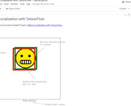
- Object Localization with TensorFlow: Coursera Project Network
- Introduction to Typography: California Institute of the Arts
- Éléments de Géomatique: École Polytechnique Fédérale de Lausanne
- Data Visualization using Microsoft Excel: Coursera Project Network
- Systèmes d’Information Géographique - Partie 2: École Polytechnique Fédérale de Lausanne


